Complete Streets Redesign — Erb Street West
As part of a requirement of our Civil Engineering degree, my capstone team completed an 8-month capstone project solving a real-world problem that brings all of the knowledge we gained from co-ops and courses together. We decided to work on a complete streets redesign of a 2.65-kilometre segment of Erb Street West in Waterloo, Ontario, on behalf of the Region of Waterloo.
We were super grateful to have received the Sovereign Asset Management Inc. Award for innovation, originality, and a strong proof of concept. And we placed 2nd at the MTE Consultants Pitch Competition 🥈.
The Street
Erb Street West is a four-lane “stroad.” It functions as a high-capacity arterial while running directly past Supportive Housing Waterloo and Beechwood Manor Retirement Home whose residents depend on it for daily mobility. Despite the City of Waterloo identifying it as a potential Stage 3 ION corridor, the street offered no protected cycling infrastructure, narrow sidewalks, and transit service that barely qualified as frequent. My team wanted to make this corridor more accessible for all.
What We Recommended in 4A
In our first term, we evaluated five design alternatives using microsimulation in VISSIM, macrosimulation in VISTRO, cost estimation, and a custom multimodal accessibility model we built in QGIS and Python. The accessibility model ran 15-minute network analyses across 32,046 road segments in the Kitchener-Waterloo region for walking, cycling, and transit, assigning travel speeds based on actual infrastructure quality and integrating Level of Traffic Stress classifications for cycling.
After comparing all five alternatives across traffic operations, pedestrian safety, accessibility, cost, and community impact, we recommended a side-running BRT as the preferred design 🚌. It achieved 72.7% improvement in walking accessibility, 44% in cycling, and 50% in transit over the baseline, and it did so with a geometry that worked within a residential-adjacent corridor rather than against it.
Detailed Design in 4B
This term, we moved from concept to construction-level detail. The work covered cross-section and plan view design in AutoCAD, microsimulation, transit scheduling, ArcGIS catchment analysis, and 3D visualization in SketchUp and Twinmotion.
3D Visualization
We built a 3D model of the corridor in SketchUp using shapefiles from the Region of Waterloo’s Open Data portal, classifying surrounding arterials, collectors, and local roads and tracing key corridor elements from that base. We also plotted an elevation profile using Google Earth data across the full length of the study area to accurately render the corridor’s topography, including its steepest sections, before bringing everything into Twinmotion for our symposium poster and presentation.


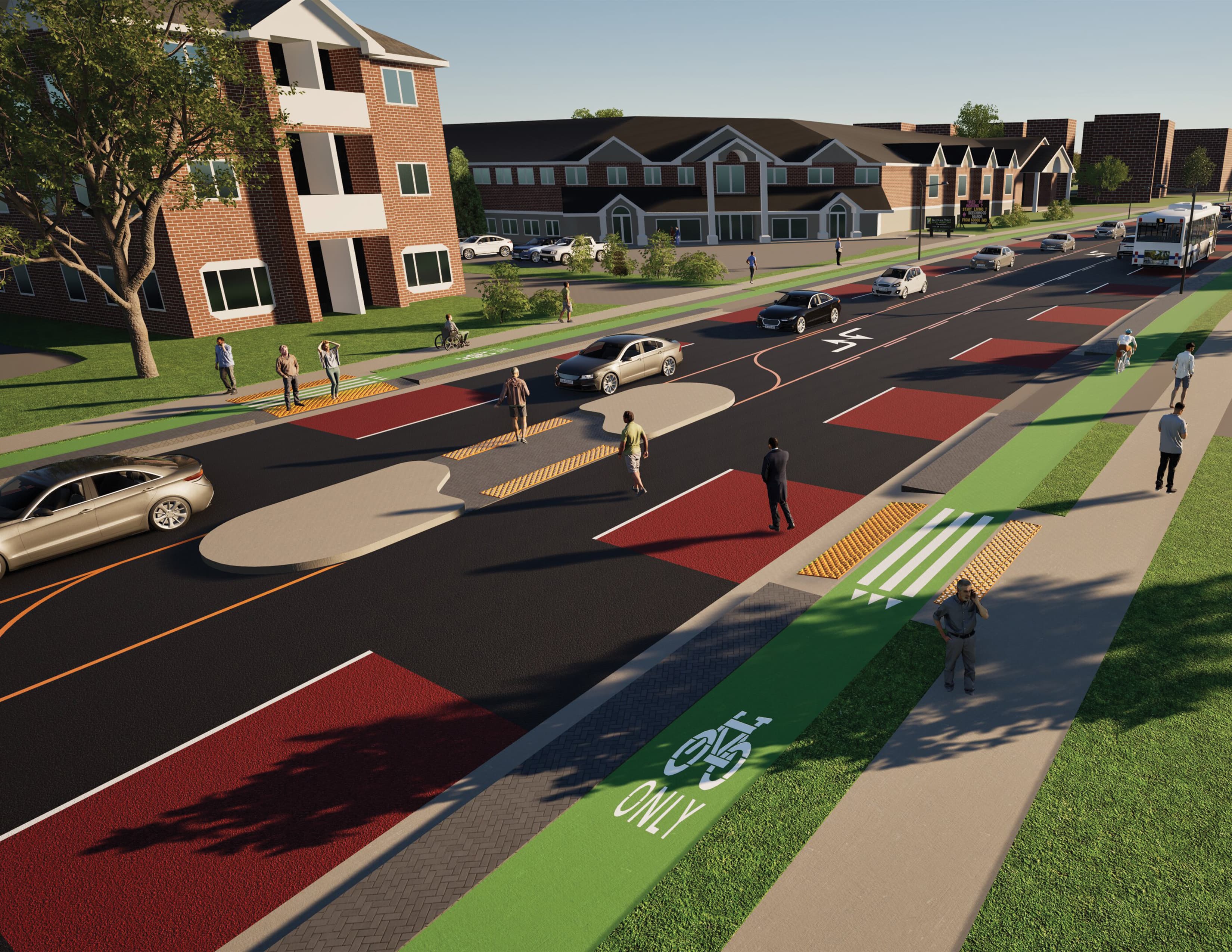
Cross Sections and Plan Views
Our typical cross section fit within a right-of-way that varied from 27.5 m to 30.0 m along the corridor. Reading from curb to curb, it included 1.50 m protected cycle lanes on each side raised to sidewalk grade, 1.0 m hardscape buffers, 3.50 m dedicated BRT lanes, 3.20 m mixed traffic lanes, and a dual left-turn lane at centre. Boulevard widths accommodated 1.80 m sidewalks and hydro infrastructure with a minimum of 4.5 m. We also drew a floating bus stop cross section, where the BRT station island was 2.30 m wide with hardscaping, and cyclists yielded to pedestrians via signage consistent with OTM Book 18.
Early in the term we met with industry professionals from the Region of Waterloo, Arup, and Salvini Consulting to stress-test the designs. They pushed us to reduce our lane widths and curb and gutter dimensions to align with regional standards, swap grass areas at floating bus stops for hardscaping for maintenance reasons, and remove bollards — a recommendation that came from both snow clearing concerns and the fact that typical bicycle handlebars sit at a height that creates real interference issues in constrained spaces. We incorporated all of it, using wider boulevard widths to provide the cycle track separation we had originally intended bollards to achieve.
The right-of-way constraint was most acute near Amos Avenue, where the ROW narrowed to approximately 24.5 m. Maintaining design consistency at that pinch point would likely require property acquisition, which we flagged in our report to the Region.
Design Decisions That Shaped the Corridor
Two design changes this term significantly shaped the proposal. The first was introducing a two-way centre left-turn lane (TWLTL) along the corridor east of Fischer-Hallman Road to University Avenue, with breaks at constrained cross-sections and pedestrian crossings. Erb Street West has a substantial number of access points, and without dedicated turning space, vehicles entering and exiting driveways would have created constant conflict potential on a corridor meant to prioritize through movement and safety. The TWLTL gave those movements their own space.
The second was adding an eastbound left-turn lane at the Amos Avenue intersection. With the dedicated BRT lane in place, the bypass opportunity that previously existed for vehicles stuck behind turning traffic disappeared. The added turn lane preserved operational efficiency without compromising the BRT’s priority.
We also refined bus stop and pedestrian refuge island placements throughout. At Amos Avenue, we relocated both bus stops to the east side of the intersection to work with the new left-turn lane geometry. The pedestrian refuge island in front of Beechwood Manor was repositioned to reduce conflicts with driveway accesses and the TWLTL — a small change that directly benefited the people this project was most trying to serve.
Transit Scheduling
The corridor is served by Route 5 (Erb) and Route 202 (University iXpress). Our proposal consolidated bus stops, removing three along Route 5 at Roosevelt Avenue, Culpepper Drive, and McDougall Street, while keeping Route 202’s stop pattern intact. With transit signal priority and semi-exclusive right-of-way introduced, we extracted inter-stop running times from our VISSIM model for both routes, both directions, and AM and PM peaks, then applied standard transit scheduling methodology to produce revised headways, fleet requirements, and cycle times. We compared two operator responses: maintaining fleet size and improving frequency, or keeping headways and reducing the number of transit units to lower operating costs.
ArcGIS Catchment Analysis
Alongside the physical design work, we built a bike-shed and walk-shed analysis using ArcGIS Network Analyst, comparing 15-minute catchment areas before and after bus stop consolidation. The goal was to verify that consolidating stops didn’t meaningfully reduce who could access the system on foot or by bike.
Our Tactile Bus Stop Sign
We made a tactile bus stop sign placed at each floating bus stop, designed to help visually impaired pedestrians safely cross the cycle track to reach the bus island. It was inspired by accessibility interventions in TransLink’s Design Guide for Bus Stops Adjacent to Cycling Infrastructure.

Wrapping Up
We presented at the CEE Capstone Symposium this spring, and I’m genuinely proud of what this team produced over the past year. The work touched everything from network-level accessibility modelling to millimetre-level cross-section decisions, and at every step it kept coming back to the same question: who does this street actually serve?
To better streets,
Adriana
© Adriana Ceric